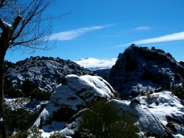
En esta foto podemos ver la cima del cerro de Los
Corralillos, muy cerca del de
Buenavista. En Agosto de 1.994, un gran incendio provocado quemó casi la mitad del parque, unas 8.000 ha. La foto está tomada 10 años después y en ella puede verse una antigua zona de
encinas en proceso de regeneración. Las
aulagas forman un tupido y espinoso matorral en el que nada puede penetrar, permitiendo crecer a las encinas por encima de ellas, a salvo de cualquier herbívoro de mediano tamaño. Este tipo de matorral presenta un
elevadísimo riesgo de incendio, y un segundo incendio conduciría a la
desertificación de la zona. Tal vez fuera el momento de conformarse con un encinar
adehesado, limpiando las aulagas que protegieron el rebrote, y no arriesgar más el futuro de la zona. Desgraciadamente, las antiguas zonas de pinar no presentan una recuperación tan prometedora. Si quiere llegar hasta aquí, simplemente siga este enla ce a
google maps.In this photo we can
see the top of the hill of Los
Corralillos,
near Buenavista.
In August 1.994, a
great arson burned near the half of the park, 8.000 ha.
The photo was shooted ten
years after the fire,
and you can
see an old holm oak area in regeneration process.
The aulagas (genistas or
brooms, but you must see the spanish link to see the
genista scorpius) are a
very dense,
closed and thorny bushes that proyect the oaks from almost every herbivorous. Aulagas can
burn very easyly,
and a
second fire (
or damned arson)
get this area in a
desert zone.
Pherhaps,
now is the moment to clean this bushes that have protected the oak regeneration.
Unfortunately,
the pine areas haven´t
been regenerated properly. If you wanto to go there, just click in this link to
google maps.